-
| - |
 |
Primary
Payload | - SRTM
SRTM obtains Earth surface
data for generating two-dimensional and three- dimensional maps of the Earth.
The obtained data will be used to generate maps of the Earth, as well as
for aircraft navigation safety and Earth science research such as floods, soil
erosion and land slides.
The details are presented here.
| - |
 |
Secondary
Payload | -

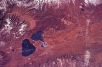
Electrophotographs taken by EarthKAM camera (Himalaya Mountains) |
EarthKAM
EarthKAM is an educational program under which middle
school students will photograph the Earth using a digital camera mounted on the
Space Shuttle.They will then use these photographs to carry out research under
various themes in science and social studies.This is a NASA-sponsored program
conducted in cooperation with the University of California at San Diego (UCSD)and
other
organizations.
This mission is a more developed version of similar
missions that were conducted under KidSat during the STS-76,81 and 86 shuttle
missions.Since STS-89,the program has been conducted as "EarthKAM".
Each school that participates in the program will study the method of selecting
and using themes on Earth photography,and will hold discussions with other participant
schools via the Internet.They will also learn about the principles of operating
the shuttle and the orbit through which it will travel.
In order to avoid
a situation in which the photographing point is covered with clouds,the students
will select candidates for photography based on images obtained from a meteorological
satellite,and send photographing instructions to the shuttle via the Internet.The
electrophotographs taken this way will be transmitted to the participating schools
on Earth several hours later.
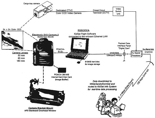
The camera to be used is a digital camera.After
the launch,the crew will install the digital camera on the overhead window of
the aft flight deck at the rear of the shuttle.Next,they will connect the digital
camera to a personal computer in the shuttle,and set it in such a way that it
can be controlled from Earth.
Apart from the work of installing and stowing
the camera and accessories,the initial pointing of the camera,and replacement
of the lens,the camera will be operated entirely from Earth without any intervention
on the part of the crew.
In EarthKAM projects up to now,more than 2,000
photographs of the Earth have been taken,based on themes such as the Himalayas,clouds
above the Pacific Ocean, volcanoes,and the large-scale forest fires in Indonesia.
Four middle schools in Japan and some schools in Germany will take part in
the STS-99 mission's EarthKAM program. This is the first time that foreign schools
will take part in the EarthKAM program. To prepare for the real operation, participating
schools took part in an EarthKAM simulation. The Mission Operation center in the
University of California at San Diego and participating schools in EarthKAM took
part in the three-hour simulation, assuming two revolutions of real operation.
Past EarthKAM projects
| Shuttle mission | Number of
participating
schools | Number of
photographs taken | | STS-76 | 3 | 325 |
| STS-81 | 17 | 533 |
| STS-86 | 52 | 670 |
| STS-89 | 37 | 490 |
Electrophotographs
taken by EarthKAM camera

Nile River, Egypt |

Morocco Plains, North Africa | |

Great Barrier Reef, Australia |

Mouths of the Ganges, Bangladesh |

Atlantic Ocean | |
EarthKAM-related home pages

Operational image of EarthKAM -

HDTV on board STS-95 | HDTV Demonstration
On STS-95, on which astronaut Mukai flew, High-Definition Television (HDTV) was
used for the first time to take video and the results were highly evaluated.
On STS-99, usability of HDTV will be evaluated further through cooperation
between Japan and NASA. Since the orbit altitude of STS-99 is 233 km, which is
lower than the 555 km orbit of STS-95, higher resolution video scenes are expected.
In addition to Earth observation, video of liquid drop movement will be taken
inside the shuttle. The quality of video scenes taken by HDTV and an ordinary
camera will be compared after landing.
| Launch Date and Time |
February 11, 2000 12:44 p.m. (EST)
February 12, 2000 2:44 a.m. (JST) |
| Launch Site | Kennedy
Space Center, Florida, Pad 39A | | Flight Duration | 11
days (plus a two-day extension due to bad weather) | | Orbiter | Endeavour
(14th flight) | | Orbit altitude | 233km
(126 nautical miles) | | Orbit inclination | 57
degrees | | Landing date and time |
February 22, 2000 6:22 p.m. (EST)
February 23, 2000 8:22 a.m. (JST) |
| Landing site | Kennedy
Space Center(KSC) | | Payload | Cargo
Bay | SRTM | | Mid-deck | EarthKAM |
( STS-99 Flight Plan BASIC (June 28, 1999))
| Flight
Day | Primary Tasks | | FD1 | Launch
& Orbit insertion, Ku-band antenna deployment and activation, SRTM On Orbit
Check Out (OOCO): Until 12 hours after lift off (Activate SRTM, extend mast, adjust
antenna position, acquire test data) | | FD2 | Observation
by SRTM (Start 12 hours after lift off) | | FD3 | Observation
by SRTM | | FD4 | Observation by SRTM |
| FD5 | Observation by SRTM | | FD6 | Observation
by SRTM | | FD7 | Observation by SRTM |
| FD8 | Observation by SRTM | | FD9 | Observation
by SRTM | | FD10 | Observation by SRTM |
| FD11 | Retract mast, terminate SRTM |
| FD12 | Prepare cabin, retract Ku-band antenna, prepare for deorbit,
deorbit, land | |
During this mission, data will be acquired around
the clock. For this purpose, the six crew members will be divided into two teams,
the RED Team and the BLUE Team. When one team is working, the other one will be
asleep, thus allowing the operation to be continued 24 hours a day.
Astronaut
Mohri will be on the Blue Team and will sleep after orbit insertion.
Members RED Team

Kevin R. Kregel |

Janet Lynn Kavandi |

Gerhard P. J. Thiele |
BLUE
Team

Dominic L. Pudwill Gorie |

Janice Voss |

Mamoru Mohri |
| Last Updated : February 23, 2000 |
|


