|
|||||

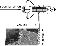
Synthetic Aperture Radar Synthetic Aperture Radar (SAR) is an active radio sensor which transmits micro-wave signals to the Earth and receives reflected signals to observe physical characteristics, ups and downs or slopes of the Earth's surface. SAR can operate day and night and is not affected by clouds or rain fall, an all-weather sensor.
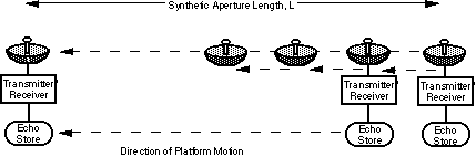
Since SAR is a radio wave sensor which uses microwave signals, generating an image of the target is not easy. This differs from ordinary cameras. Generating images from the obtained data requires a tremendous amount of data processing using computers. SAR transmits more than 1000 pulses a second to the ground as it travels along a straight line and receives reflected pulses. SAR receives both the amplitude and phase of the reflected waves, whereas ordinary radar detects amplitude only. As a satellite or aircraft equipped with SAR moves, SAR receives reflected data from one target at different locations. By processing received data, high resolution, equivalent to that of a large antenna, is possible, even though a small antenna is used. This is equivalent to utilizing many small aperture radars to obtain similar effects as a large antenna. Since this radar uses synthesized apertures, it is called "Synthetic Aperture Radar".
The US marine observation satellite SEASAT began observing the Earth from space utilizing SAR in 1978. Since then, SAR Earth observations have been performed by Japan's Earth Resource Satellite 1 (JERS-1), ESA's ERS-1 and ERS-2, and Canada's RADARSAT. Also in Japan, the Communications Research Laboratory (CRL) and the Geographical Survey Institute (GSI) are conducting observations using SARs on board aircraft.
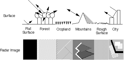
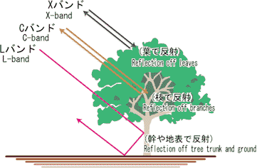
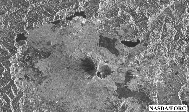
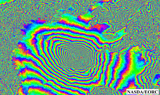
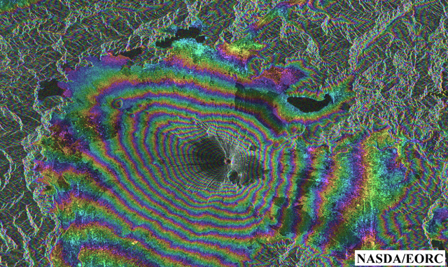
Taking a forest as an example,radio waves in the L-band penetrate the leaves,but are reflected off the tree trunks and the ground.Waves in the X-band are reflected off the leaves,while waves in the C-band are reflected off both leaves and branches, and, depending upon the conditions,they are also reflected off the tree trunks and the ground.Because of these characteristics,L-band waves enable determining the distribution of vegetation and the kind of vegetation in a tropical forest or northern forest,for example.They also enable detecting the existence of vegetation,changes such as the shrinking of forests due to logging or forest fires,or the recovery of forests due to planting.Research is being carried out on C-and X-band waves with a view to using them to classify vegetation,including that on farmland and grassland,by utilizing the difference in the intensity of the waves reflected off leaves and branches. The applications of a SAR are not limited to forests,but embrace a wide range of fields including geology,prevention of natural disasters,agriculture,detection of snow and ice, oceanography,and planetary exploration.SARs of wavelengths matched to these applications are mounted on aircraft and artificial satellites,and used for observing the entire Earth. Japan Earth Resources Satellite-1 (JERS-1),which carries a 23.5 cm wavelength L-band SAR,is effective for resource exploration because of the characteristics of this wavelength. This satellite was decommissioned in October 10,1998. However,the data acquired over its six-years life is still being utilized in many fields of research and practical applications. Interferometry and Three-Dimensional Map Generation The technique used to generate height difference information of the Earth's surface by observing a location from two separate positions with a SAR is called interferometry. The image generated by this technique is called an interferogram. However, an interferogram is just a group of interference stripes, so it can indicate only relative height differences. In order to obtain standard height information, the interference stripes will be compared with known heights, and the height data will be processed to generate three-dimensional images.
Three Dimensional Observation Principle If one location is observed from two different points, three-dimensional image can be obtained. It is the same as viewing an object with two eyes. In case of SRTM, the 60m mast length corresponds to the eye separation, and the two antennas correspond to two eyes. Continued to "Detailed Description of SRTM Observation Principles (2)"
| |||||||||||||||||||||||||||