
| SRTM Observation Principles |
|
 |
| NASA/JPL/Caltec |
SRTM, the primary mission of STS-99, collects Synthetic
Aperture Radar (SAR) data necessary to generate a high-precision, three-dimensional
Earth surface map of all of the land area, between 60 degrees north to 54
degrees south. The observation area covers about 80% of Earth's land area.
During the STS-99 flight, data will be collected by two SARs, and a three-dimensional
map will be generated
by applying interferometry
techniques to these two sets of data.
Earth observations using SAR were conducted on Space Shuttle missions,
STS-2, 41G, 59, and 68. Partial three-dimensional maps were generated by
applying interferometry techniques. However, it took several years to generate
three-dimensional maps from data collected on the previous missions since
necessary data had to be collected by more than two Shuttle missions, the
orbits of which are slightly shifted from each other.
Three-dimensional maps generated by data with the precision of that collected
by STS-99(horizontal accuracy 30m, and vertical accuracy 16m) have been
generated for only four percent of the whole land area.This means that
it should be possible to clearly recognize a large building or a stadium,for
example.
At present,topographic maps of the entire Earth have a resolution of only
1,000 m in the horizontal direction,and 100 m in the vertical direction,hence
it is difficult to obtain an accurate grasp of the Earth's topography.
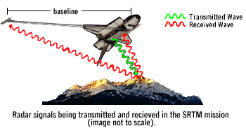
On mission STS-99, an antenna will be located in the Shuttle cargo bay,
and a dedicated receiving antenna will be located at the end of the 60m
mast. Collecting data with these two eyesireceiving antennasjwill provide
data with unprecedented observation accuracy and coverage. High-resolution,
three-dimensional maps can be generated by applying interferometry techniques
to these data.
| Last Updated : September 1, 1999 |
|